
Although Poverty Point in Louisiana is not a proper megalithic site, we decided to include it in the megalithic archive because the main structures of Poverty Points are monumental earthworks culminating in a main pyramid-shaped mound.
The culture that built the site extended 100 miles (160 km) across the Mississippi Delta and south to the Gulf Coast.
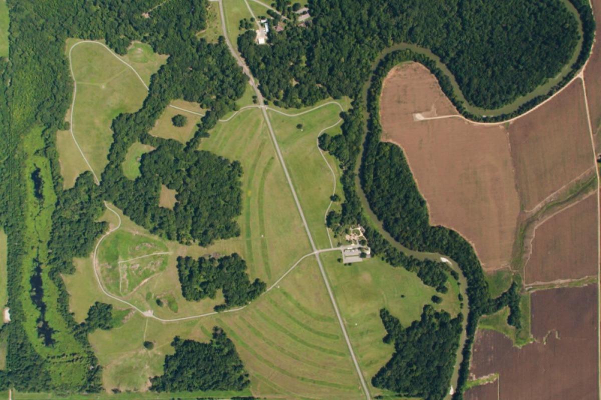
Poverty Point in Louisiana has been designated as a U.S. National Monument, a U.S. National Historic Landmark, and UNESCO World Heritage Site. Located in the Southern United States, the site is 15.5 miles (24.9 km) from the current flow of the Mississippi River and is situated on the edge of Macon Ridge, near the village of Epps in West Carroll Parish, Louisiana.
The earthworks were completed by indigenous people between 1700 and 1100 BC during the Late Archaic period in North America. Archaeologists have proposed a variety of possible functions for the site including as a settlement, a trading center, and/or a ceremonial religious complex, defining it “the largest and most complex Late Archaic earthwork occupation and ceremonial site yet found in North America”.
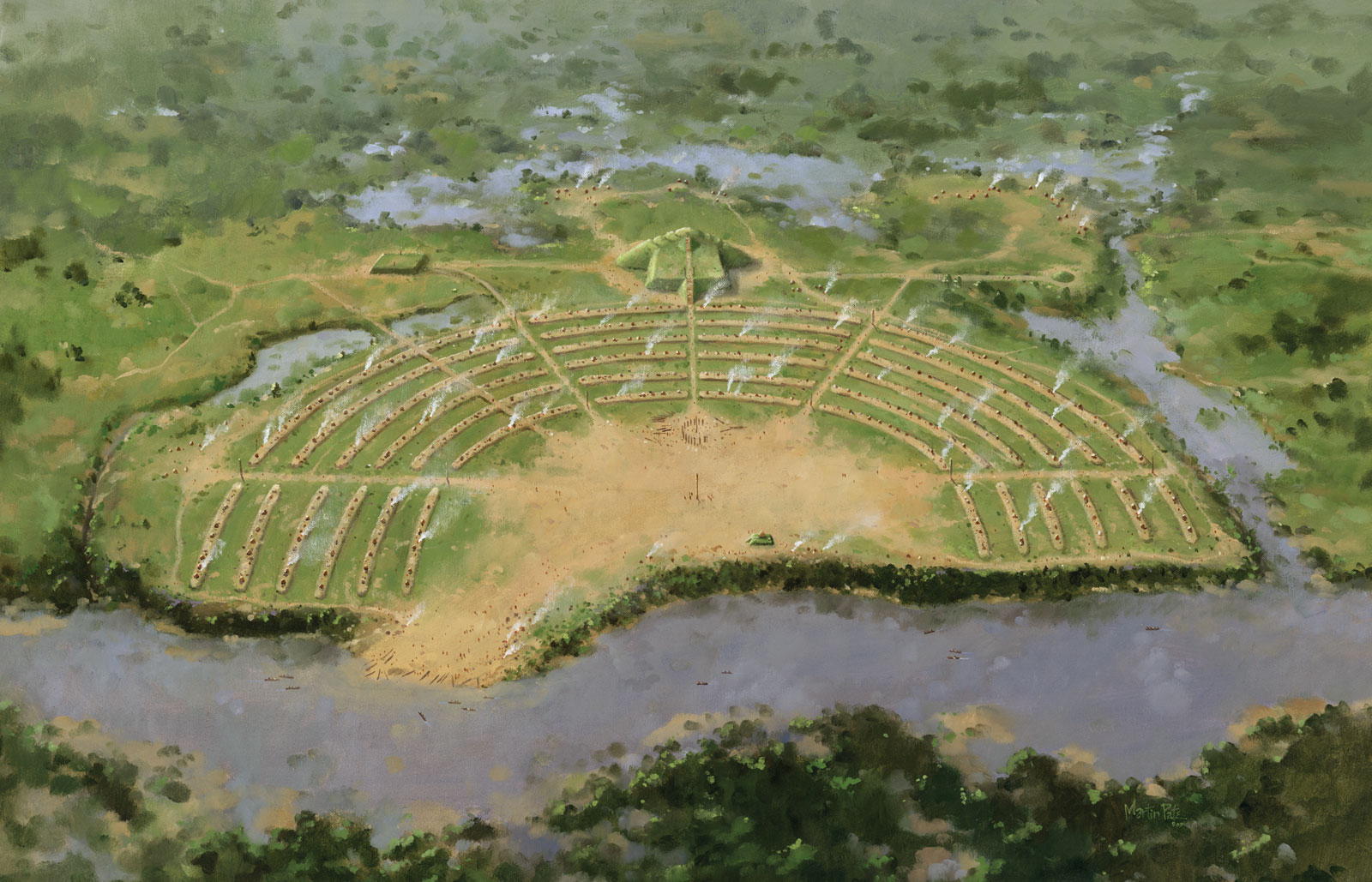
The Monumental Earthworks of Poverty Point in Louisiana consist of a series of earthen ridges, earthen mounds, and a central plaza.
The main part of the monument consists of six concentric C-shaped ridges. Interestingly, it seems to have been constructed in a way that resembles Plato’s description of Atlantis, like several other ancient sites.
Each ridge is separated from the next by a swale or gulley. The ridges are divided by four aisles forming earthwork sectors. Three additional linear ridges or causeways connect earthen features in the southern half of the ridges.
Today the ridges vary from 0.3 to 6 ft (10 –185 cm) in height relative to the adjacent swales. Archaeologists believe they were once higher in places but have been worn down through roughly 150 years of agricultural plowing.
The slightly rounded crest of each ridge varies from 50 – 80 ft (15–25 m) in width. The width of the intervening swales is 65 – 100 ft (20 – 30 m). The approximate diameter of the outside ridge is three-quarters of a mile (1.2 km), while the innermost ridge’s diameter is about three-eighths of a mile (0.6 km).
The scale of the ridges is so massive that it wasn’t until researchers examined aerial photographs that they were able to recognize the geometric design.
Radiocarbon dates suggest that most of the ridges were constructed between 1600 and 1300 BCE.
The biggest mound is referred to as Mound A, which is 72 ft (22 m) tall at its highest point and about 705 x 660 ft (215 x 200 m) at its base, and judging by its reconstruction it clearly appeared much more like a pyramid that a classic mound.
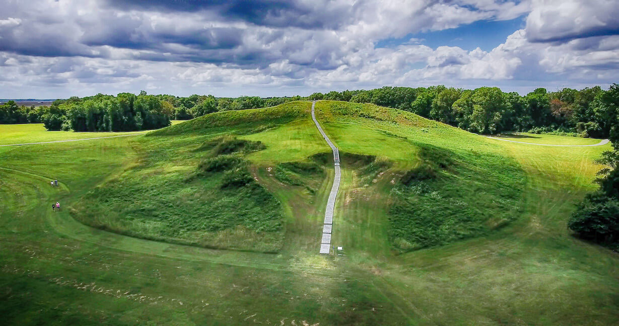
Mound A is located to the west of the ridges and is roughly T-shaped when viewed from above. Some have interpreted Mound A as being in the shape of a bird or as an “Earth island” representing the cosmological center of the site.
There are no signs of construction phases or weathering of the mound fill even at microscopic levels, indicating that construction proceeded in a single massive effort over a short period. In total volume, Mound A is made up of approximately 8,400,000 cubic feet (238,000 cubic meters) of fill, making it the second-largest earthen mound (by volume) in eastern North America.
It is second in overall size to the later Mississippian-culture Monks Mound at Cahokia, built beginning about 950-1000 AD in present-day Illinois near the Mississippi River.
Interestingly, near the Poverty Point area are two mounds that archaeologists believed were built during the same period.
Approximately 1.8 miles (2.9 km) south of the site is the Lower Jackson Mound, a conical structure 10 ft (3 m) in height and 115 ft (35 m) in diameter at its base.
Modern radiocarbon dates from the base of the Mound demonstrate that the Lower Jackson Mound was built ca. 3900 to 3600 BCE which predates the Poverty Point earthworks by about 1500 years.
Lower Jackson Mound is on the same north-south line as the later Poverty Point Mounds E, A, and B.
Approximately 1.2 miles (2.2 km) to the north of the Poverty Point earthworks is the Motley Mound, which is 52 ft (16 m) in height with a base that measures 560 x 410 ft (170 x 125 m). Motley Mound has some similarity in form to Mound A, however, the cultural affiliation of this earthwork remains speculative.